North Scottsdale

Scottsdale coverage area
This page collects SAZLive stories tagged to North Scottsdale. Official city policy documents for parts of the city’s north include the Desert Foothills Character Area Plan, adopted in June 1999 (generally between Dixileta Road, Jomax Road, the western city boundary, and 96th Street), and the Dynamite Foothills Character Area Plan, adopted in March 2000 (generally between 112th Street, the eastern city boundary, Deer Valley Road, and Lone Mountain Road). The McDowell Sonoran Preserve, a city preserve of more than 30,500 acres with more than 230 miles of multi-use trails, is also in northern Scottsdale.
SAZLive uses these pages as coverage areas for tagged stories. They are not official city limits. Homeowner-association and community lines often overlap.
Sources
Sources checked Nov. 15, 2026.
- Desert Foothills Character Area Plan — June 1999 adoption; general bounds Dixileta, Jomax, western city boundary, 96th Street
- Dynamite Foothills Character Area Plan — March 2000 adoption; general bounds 112th Street, eastern city boundary, Deer Valley Road, Lone Mountain Road
- McDowell Sonoran Preserve — More than 30,500 acres and over 230 miles of multi-use trails
Latest in this file
SAZLive sportsHigh school Friday night
Sports
5A football quarterfinals Friday: Canyon View at Desert Mountain, Cactus at Notre Dame Prep, Cactus Shadows at Horizon
Three 5A state football quarterfinals are at Scottsdale-area schools at 7 p.m. Friday, Nov. 20: No. 1 Desert Mountain, No. 3 Notre Dame Prep and No. 2 Horizon host.
SAZLive sports
Sports
Notre Dame Prep sweeps Chaparral for the 5A girls volleyball state title
Notre Dame Prep beat Chaparral 3-0 (26-24, 25-12, 25-20) for the 5A girls volleyball state championship on Nov. 14, according to the AIA state bracket.


Events
Arabian Library hosts Music Under the Stars on its patio Thursday, Nov. 19
Arabian Library will host its monthly Music Under the Stars concert on the library’s central patio at 6:30 p.m. Thursday, Nov. 19.

Events
Liberty Wildlife brings Arizona birds of prey to Appaloosa and Civic Center libraries Nov. 17–18
Presenters from Liberty Wildlife will bring birds of prey native to Arizona to two Scottsdale libraries on Nov. 17 and 18.

Events
Goodguys Southwest Nationals brings 3,000-plus classic cars to WestWorld Nov. 20–22
The Goodguys Southwest Nationals car show returns to WestWorld of Scottsdale, 16601 N. Pima Road, from Friday, Nov. 20, through Sunday, Nov. 22.


Community spotlight
Events
Historian traces Curry’s Corner and Rawhide at Appaloosa Library Nov. 18
Scottsdale community historian Joan Fudala will give a photo-rich talk on the history of the land under Appaloosa Library at 5:30 p.m. Wednesday, Nov. 18.
Civic
North Scottsdale roadwork: Dynamite closed east of Scottsdale Road, Pima Road lanes narrowed
Several long-running construction zones in north Scottsdale stay in place the week of Nov. 16, and two Loop 101 ramp restrictions are listed, according to the Arizona Department of Transportation’s AZ511 work-zone data, retrieved Sunday, Nov. 15.

Civic
City boards meet the week of Nov. 16, and Planning Commission holds a Nov. 17 hearing
The City of Scottsdale's official weekly update dated Nov. 9, 2026, listed these public meetings for the week of Nov. 16.


Desert Living
A stretch of Tom’s Thumb Trail is closed after a boulder shift
The City of Scottsdale says a section of Tom’s Thumb Trail is closed after a large boulder and unstable soil were left by recent rain.

Desert Living
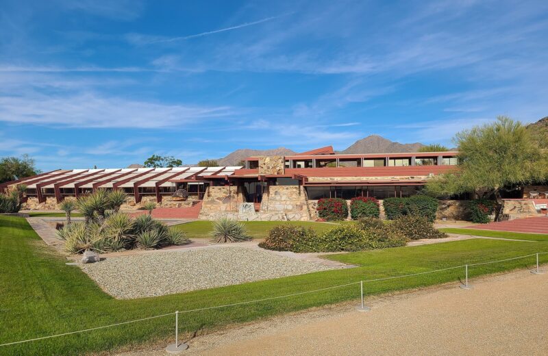
Taliesin West is open for tours at Wright’s desert laboratory
Taliesin West, Frank Lloyd Wright’s winter home and desert laboratory in the foothills of the McDowell Mountains, is open to the public for tours.
Desert Living
Ashler Hills Park adds pickleball and paths in far-north Scottsdale
Ashler Hills Park, at 32220 N. 74th Way, is a far-north Scottsdale city park whose official Find a Park listing includes a playground, pickleball courts, a basketball court, multi-use paths and restrooms. Park hours are listed as sunrise to 10:30 p.m. The park page was marked updated May 12, 2026.


Civic
City reopens Monterra at WestWorld as a year-round event venue
The city has reopened Monterra, the event venue at WestWorld of Scottsdale, as a year-round rental after taking over its operating rights and renovating the…